


The Map view displays incidents and alerts in the map area of interest. This initial view is presented to the user based on the default district indicated in the user's profile. The primary features of this page allow the viewer to visually inspect existing lane closures, filter events by date, and view the types of incidents and their locations as reported by VaTraffic. The following diagram and the content below describes some of the features available in the main window of LCAMS:
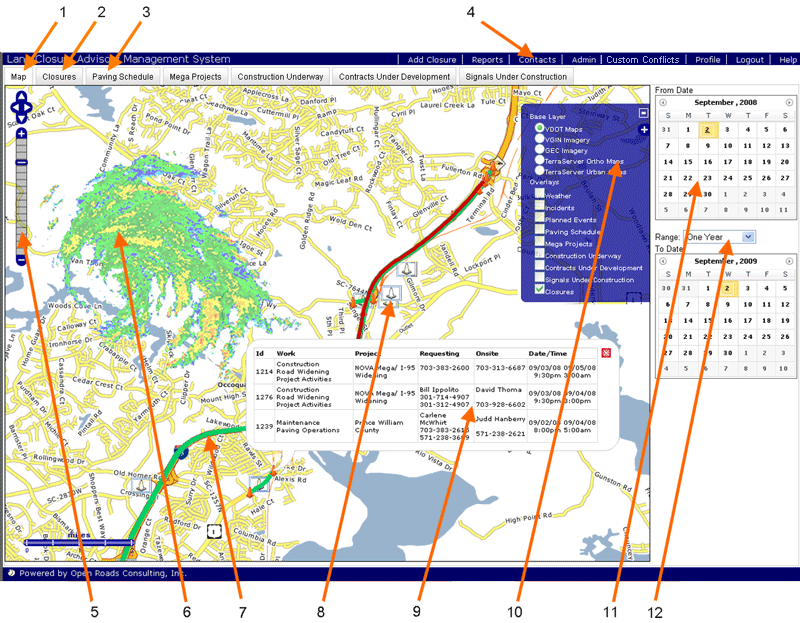
1. Map View tab - The display above highlights lane closures, incidents, and alerts in the area of interest
2. List View tab - Use this tab to view a detailed description of the scheduled and active lane closures within the specified date range
3. Project Coordation tabs - Project Managers interested in coordinating efforts across organizations use these process/planning tabs
4. Navigation Bar - Click a selection to access different functional areas
5. Navigation Controls - Use these buttons to zoom, look, and move around
6. Weather - Live weather data is fed into the system every five minutes to quickly provide access to regional weather patterns. This layer can be disabled.
7. Lane Closure - Scheduled closures are indicated by a mapped line segment with orange-colored cones marking the endpoints. Lane closures are color-coded by status and may be clicked on to display detailed information.
8. Traffic Incident - These icons provide an intuitive method to quickly identify incidents by type and location as provided through VaTraffic. This layer can be disabled.
9. Pop-up Information Window - To show detailed information, click on a lane closure to display the informational pop-up window. If multiple closures are detected, they are stacked.
10. Layer Control Panel - Activate this control to enable/disable various visual layers such as those for weather and traffic
11. Calendar - The calendar option is helpful, allowing lane closures to be filtered by start/end dates
12. Date Range filter - Used in conjuction with the calendar, this tool synchronizes a start/end date to a desired range